Catch-up
Continuing on from Earthquake- Marfells Beach & Mussel Rock
There were even greater changes around Cape Campbell and down the coast at Ward Beach; closer to Kaikoura and the epicentre of the earthquake. That's the old high tide line at least 30-60cm (1-2 feet) above David's head and the new high-tide line where the green algae ends.
November 2017

Ward Beach, like Marfells DOC Camp, was a regular stop-off point for us before the November 2016 Kaikoura Earthquake. We often spent a few nights at one or the other on our way up State Highway 1 to catch the ferry or when heading south again after a North Island visit. After the 'quake and due to the major damage done to the road and rail network, SH1 was closed at Clarence, 45kms south of Ward.
July 2014
 |
| High tide |
The camping area is beside rugged & wild Ward Beach and is located on land that belongs to a local farmer. The site is actually right next door to the Ward Beach Reserve where no camping is allowed, but open the gate and drive on through & anyone with a CSC (certified self-contained) vehicle can camp on the other side of the fence for a small donation to the farmer, to be left in his letterbox back up the road.
February 2015
 |
| Low tide |
Once again I've been able to compare pre-'quake photos I had of Ward Beach with the ones I took when we visited the beach while staying at Marfells. I didn't have too many that are direct comparisons but you can still see a huge difference in the rocks that protect each side of the tiny beach (I have no idea why I didn't think to check the old ones out before the visit so I could take the new ones in the same spot!).
Remember to click the first photo to take you to a slide show and then use your back and forward arrows to view them enlarged and side by side.
November 2017- After the 'quake showing the rocks to the left of beach. In the two photos above you can see the same rocks before the event.

February 2015- down on the beach

November 2017- This photo is a bit deceptive because the rocks you can see in the photo above are the rocks on the hard left and out of shot in the photo below. The rocks on the right were under water above.

February 2015- before the earthquake a local crayfishing company launched their boats from a 'dozer at the beach most mornings. Since the 'quake, they have been unable to due to the shallow bay and exposed rocks. They have also been unable to get resource consent to launch them further up the coast. Sadly, they have become another one of the many businesses up and down the Kaikoura Coast that have suffered in the aftermath of the 'quake.

November 2017- the vertical slabs of rocks on the right appear to be the same ones behind the boat in the photo above.

July 2014- On the right-hand side of the small beach the Flaxbourne River flows into the sea.

November 2017- you can certainly see the difference here after the 'quake, the gravel banks on both sides of the river and the rocky outcrop at the outlet have been pushed up...

...blocking off the river mouth- November 2017.

February 2015- before the 'quake and on the other side of the rivermouth looking back towards Ward Beach

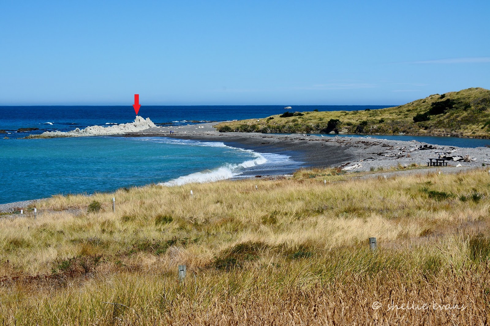
February 2015- an arrow marks submerged rocks...

November 2017- that are now exposed.

And three more comparison shots.
Two photos from slightly different angles- February 2015

And the comparison shot- November 2017

It's not until we get up close to the rocks on the left side of the beach that it becomes apparent how far the earthquake has actually lifted the seabed. Before the 'quake most of these would have been under the water with just the tops of the bigger rocks sticking out in the wave zone.

The rocks now tower over us as we walk around them- before the 'quake we'd have had to wear wetsuits, fins and a snorkle to explore. Green algae grows below the new high tide line.

The rock David is examining is now 'beached' with no low tide mark on this side, yet the high tide line before the quake is 30-60mm above his head.

Up close, the remains of seaweed and shellfish cover the crumbling rock.

Dried stumps of seaweed...

...long dead shellfish hiding in their rocky holes and large carpets of barnacles are all that remain on the bleached rocks.

The rocky reef and papa rock platform at Ward Beach was once covered in great trails and thick forests of bull kelp that swirled back and forward in the waves, rising and falling with the tide.
February 2015-

This was once home to a diverse coastal ecosystem; crayfish, paua (abalone), green-lipped mussels, other shellfish and fish lived and sought shelter in the channels and caves around the reef.
And this was the heartbreaking sight that greeted locals in the days after the 'quake (photo supplied).
And this was the heartbreaking sight that greeted locals in the days after the 'quake (photo supplied).
November 2016

One year on and the coastal landscape has gone through another dramatic change from those early days after the Kaikoura Earthquake.
November 2017- taken from the same position as the photo above (coincidentally)

I know that there were several RVers parked at Ward Beach (and Marfells) on the night of the 'quake; we met a couple who had been at the beach a few days later at our Franz Josef camp site- they were still visibly shaken. They had dashed as far away as they could from the continuous aftershocks, along broken roads and past crumbling buildings, to the West Coast.
They were still cleaning up their van after the violent jolt threw open their drawers, cupboards and fridge and dumped clothes, crockery and food in one big broken jumble on the floor. They had to climb over the pile, in the darkness, to get to the door to escape. After the initial big shake and with the worry of a tsunami, they gathered together with the other campers in the darkness and then all made their way back up the road to the farm homestead, cautiously checking for rock slides along the way.
In time people will forget how the beach looked before the 'quake or not even be aware of the dramatic changes that happened back in the middle of a dark night in November 2016. It will still be a wild and beautiful beach with amazing sunrises.
 |
| July 2014 |
And people will still come to steal a quiet moment, sitting in their cars mesmerized by the crashing waves or sheltered from howling wind. They'll still come to relax, fish or explore the rocky shoreline (now with even more rocks and pools) and should they know of it's history, marvel in wonder at Mother Nature's incredible force.
 |
| July 2014 |
Thanks for these comparative photos - really interesting. Your closing paragraphs here are so true. This is but a small fraction of a blink in geological time. The coast is still beautiful, although it will always be slightly different from now on, and the coastal life will return. We humans certainly don't like it when things change so suddenly, but that is what has been so fascinating to the scientists studying this uplift & other interested people. Awesome is really the only word for it. So sorry for the poor people caught up in the shaking though.
ReplyDeleteIt is a shame that the fisherman can not get permission to launch elsewhere - how unnecessarily harsh. Cheers for now, Melanie.
You summed that up perfectly Melanie, it's but a tiny moment in time. Thanks for your comments, much appreciated.
DeleteDo the colourful stones still exist on Ward beach?
ReplyDeleteI'm not sure, there is certainly a lot of shingle & larger stones. Lots of white ones too but I'm not sure about coloured.
Delete