Catch-up
We did another 4WD expedition on Easter Sunday and this time managed to join two more travel dots- Bannockburn to Duffers Saddle. We left the road at Quartzville which is just behind Bannockburn in Central Otago. Quartzville was once a service town for several gold mines higher up the Carrick Range.

The track is a bit narrow and lumpy to start with, we hope we don't meet anyone coming down as there's nowhere to pass for a kilometre or so.

As we climb higher the lake and Cromwell come into view behind us. The Carrick Range forms the southern boundary of the Clutha Valley, Lake Dunstan & Cromwell. The Pisa Range runs along the left hand side of the valley and the Dunstan Mountains are along the right.

Off to our left and far below are the colours of autumn and the green of irrigated farmland behind Bannockburn. The road to the Nevis Valley runs through the valley; another 4WD track, the Hawksburn Road, heads over the Cairnmuir Mountains in the background to Clyde. We drove that 'road' last year.

Thankfully the track is dry and we make steady progress, climbing higher and higher. There were over 40 mines up here and in the nearby ranges during the height of the gold rush through the 1860s. Mines with weird and wonderful names such as these-
1. The Elizabeth. 2. Royal Standard. 3. Star. 4. Heart of Oak - later Last Shot. 5. Young Australian. 6. Caledonian. 7. Border Chief. 8. Crown and Cross. 9. Day Dawn. 10. John Bull. 11 Norwegian. 12. Perseverance Reef. 13. Perseverance Claim. 14. Veil of Avoca. 15. New Royal Standard. 16. Golden Star. 17. Dawn of Hope. 18. Duke of Cumberland. 19. Rob Roy. 20. Matchless. 21. Excelsior - afterwards Welcome. 22. Black Horse. 23. Coleen Bawn. 24. Nil Desperandum. 25. Patience. 26. Leader. 27. Robert Burns. 28. Golden Gate. 29. All Nations. 30. Kohinoor, or Amateur. 31. Golden Phoenix. 32. Heart of Lothian. 33. Enterprise. 34. White Horse - later Try again and Last Chance. 35. Golden Crown. 36. United Bannockburn. 37. Bonanza -later Frying pan. 38. Go by.
Here we pass by the site of the Caledonian. The signposts look very familiar, they are the same as the ones that mark the gold mines through the Nevis Valley on the far side of this range.

I say we made steady progress, and we did but it included many stops to take photos of the view opening up behind us. It would seem the resident merino sheep like the views as well, everything I step out, it's onto a road covered in sheep poo and smelling strongly of urine- they must sleep on the road at night and head off into the scrub during the day.

Other than a couple of mountain bikers in the carpark at the beginning of the track, we hadn't seen a single person on the 7 kilometre climb to the remains of Carricktown. So it's a great surprise as we come over a brow in the track to see ahead of us, not only the remains of Carricktown, but two girls sitting beside one of the old stone cottages having lunch. Where the heck had they come from?
These two German girls, who were not ideally dressed for such a rugged walk in the mountains, had nothing better to do on a quiet Sunday in a sleepy Bannockburn so decided to walk to the Young Australian Waterwheel which was still another two kilometres or so further on.

Carricktown was built to also service the surrounding mines and as a result of being closer, Quartzville, at the bottom of the track, was abandoned soon afterwards.

How's this for a view from your front door? Straight down the Clutha Valley. Of course back then there was no lake, just the mighty Clutha flowing through the valley. Lake Dunstan is a manmade hydro lake formed during the 1980s when the Clutha River was dammed at Clyde.


We carry on passing through a couple of shallow bogs as the track zig-zags its way up the side of a steep slope. We stop in a rough gully...

...where the remains of the Elizabeth Reef stamper battery are, along with tailing piles which are also known as mullock heaps.

We're now climbing above the winter snow line, there's a lack of briar bushes and prolificacy of Spiny Spaniard or Speargrass, an alpine plant that loves the cold and snow.

We're nearing the top of the first ridge now and I can see the track disappears over the top further on so we stop for a last photo looking back down the valley. You can just about see it here, the confluence of the Kawarau River, the lower blue ribbon of water, and the Clutha River, which is actually part of Lake Dunstan and leaves the lake at the right flowing through the Clutha Gorge to the Clyde Dam.

We pass the remains of two large, shallow dams that were obviously used in mining operations and with...

...one last gate to open and shut...

...we arrive at the site of the Young Australian gold mine and the Carrick Water Race...
 |
| The top track is the road ahead of us (if you look carefully you can see a running blue blob), the lower track is the water race. |
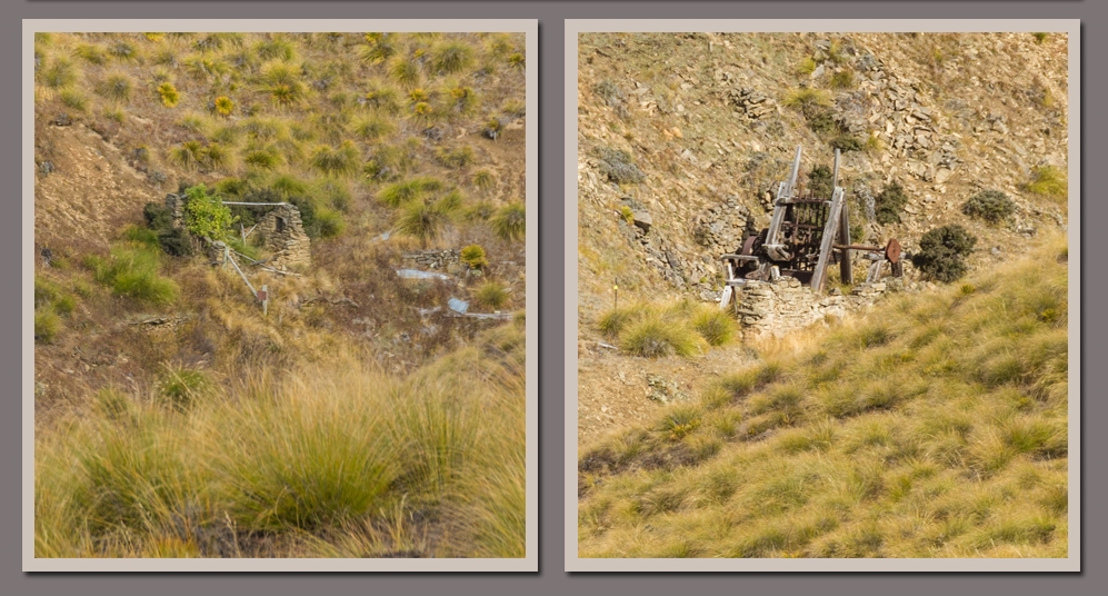
...and the 7.9m diameter wood and iron waterwheel (restored in 2011) which, in 1874, was dragged 1100 metres up the mountain to drive the 10-stamper battery at the Young Australian workings.

Looking totally incongruous in the barren and dry mountain landscape, the waterwheel drove the stamper battery which pounded the hard gold bearing quartz rock to gravel.

Across the valley from the wheel are the remains of the battery and a couple of stone huts.
The 34km Carrick Water Race was speedily built between 1872 to 1874 to bring water from the isolated Nevis Valley, over the mountains and down to Bannockburn, the water sold to miners along the way.

There were many bitter legal disputes as miners thought they'd purchased the water completely and objected to the race owners re-selling to other users further down the mountain.

What fabulous history Shellie.
ReplyDeleteThanks Carol, don't you just love this history stuff? It's hard to reconcile what went before.
DeleteHi Shellie, How lovely to find your wonderful blog. I have enjoyed your photos on group sites too. I recently went on a tour of Central Otago and travelled the same roads with their rich history so it's great to explore it all again on your site with time to absorb the details. I was on an escorted tour so unable to randomly stop and wander about taking photos, as I love to do, but the tour was great. However I now see all the views I wanted to take so thankyou for sharing your very interesting wanderings! Regards, Mary-Jane Hoult.
ReplyDeleteThanks for your lovely comments Mary-Jane, much appreciated. And I'm glad you've enjoyed ready the blog and matching some of the places with your travels.
DeleteIf you'd like to get notification of each blog as they're posted you can sign up to receive emails on the right hand side of the blog, back up the top (if you haven't already of course!).