Once we'd finished exploring the deserted camp at Haldon Arm, Lake Benmore we started thinking about heading for home. But which way? The thought of a 60+km trip back over the same road wasn’t too appealing.
In my map book, a road left the campground in the opposite direction, it branched a little further on where one road followed the Tekapo River all the way back to Lake Tekapo & home, the other road followed the Pukaki River to Lake Pukaki. The Tekapo River route was 40kms long but then it looked like there wasn’t an exit at the other end- imagine that, driving all that way and not being able to get out. The Pukaki road looked to be about 20kms and then another 30kms along the main road back to Tekapo. We decided to drive the Pukaki River route.
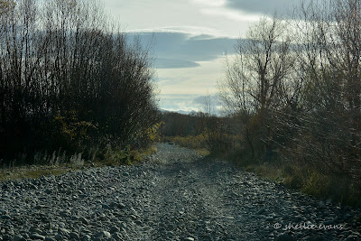
As we pulled out of the camp, the road (I use the term loosely) was all gravel and rocks. Hmmm….this should have been a warning, but we thought maybe it was just like this at the beginning and it might smooth out a little once we moved away from the lake.
Well it did, but not much. I know you’ll be sitting there thinking that doesn’t look too bad, but believe me it’s a bumpy ride. I felt like we were following the ‘Rabbit Proof Fence’, which of course we were. I wondered what covered this land before rabbits & briar bushes were introduced?
After a few kilometres we arrived at the split in the road. Mr TomTom kept flashing us a warning ‘No Road, No Road, turn around at the next possible place’- we should have heeded his warning.
But once again we thought, surely this will level out a bit more now that we’re in the open and, hey, there’s even a road sign pointing the way.
I was a little worried when I saw on the map that we’d have to ford the Tekapo River and not knowing how deep or wide it might be, we might have been in a little trouble. It was a relief to find a narrow steel bridge over it.
It was about now that we thought perhaps we should turn around, at least the 60km gravel Haldon Road was smooth and reasonably straight. But we were already about 5kms into the journey and hey, there’s only another 15 or so to go. I’ve said it before & I’ll say it again, I know a lot will be thinking 5kms is not much, but when you’re only travelling at an average of 10-15kph it’s a bloody long way.
Oh look, there’s Mt Cook! Not much further now. Yeah right.
In case you’re wondering about the colour difference in the photos- some are taken through the green tinted front screen of the ute while others are taken when we’ve stopped for a breather (and to rest our sore posteriors after all the bumping about).
The road went on and on as we eagerly counted down the kilometres. The rocks didn’t get any smaller and in some places got even bigger. The fence also went on and on, it intrigued me to see that rocks were lined up all along the bottom of the fence- to stop rabbits burrowing underneath- but from which side I wasn’t sure. And I wonder whose job it was to stack miles and miles of rocks.
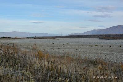
The track (I’ve taken to calling it a track now- my butt is starting to ache) came in close to the river bed on numerous occasions- usually as the rocks got bigger. This is a huge river bed, a couple of hundred metres wide but a river bed with no water. A bit weird, and I’m not sure if it ever has water in it. Of course the water that would have once filled this river has been diverted into a hydro canal. Perhaps in early spring when there’s a lot of snow melt there is a overflow down here but looking at the scrubby plants growing in the bed I don’t think it would be much anyway.
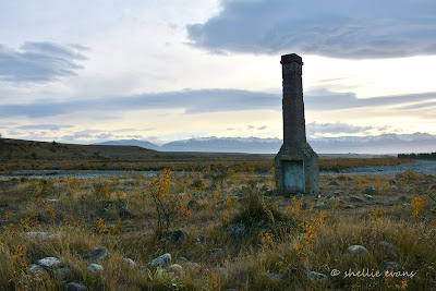
Ahead of us on the horizon I can see a chimney, it’s not hard to spot given that other than the few wildling pines it’s the tallest thing around for miles. But where did it come from, it looks totally out of place. This is the Pukaki Inn chimney. The chimney is all that remains from one of the original accommodation houses in the area. When there was a river running past. It’s thought to have been constructed in the 1920s and it’s still another 7kms from here to the Pukaki Spillway & the main road so I guess unless you’re biking or 4WDriving, not too many people would get to see this. Another hidden 'gem'.
The track climbs to a high point above the river bed and out on the edge of a cliff I find that it’s a long way down. I needed my little stickman to be down there to give you perspective. Ooh….look there’s the chimney back there, to the left of that grove of trees. This was once a massive river.
This must be the oddest sign I've seen on our travels- but first, I’d like to know how they managed to get this far.
As you can see the rocks never got smaller, it was a long and bumping ride. Of small consolation was that there was no dust. A very small consolation. We began wondering what would happen if we had a puncture. One would have been OK, but what about two? I told David he'd be the one walking for help.
And then finally ahead of us we could see the Pukaki Spillway with a stream of tiny cars passing along the top; the main road traffic. There was a deep pool of turquoise water at the base of the spillway but no flow (of course) downstream.
One hour 30 minutes and 20kms later we finally popped out onto the main road and that magnificent view (and our first on this trip) across Lake Pukaki to Aoraki Mt Cook.
I said to David- ‘Next time I want to see Mt Cook, could we take the main road?’
While I wouldn’t say we’re glad we did that trip, I couldn’t say we’d rather we hadn’t either. The first half was great, the lake stunning, the views spectacular. Whereas the second part was interesting (for the first couple of kilometres anyway) and somewhere not too many people would have travelled.


All the same I'm glad your bottom did this trip, so that mine doesn't need to...and in your words...it's a bloody long way! On the subject of bottoms, I've been using mine rather allot lately. Keep em coming...blogs that is!
ReplyDeleteYes, it's definitely not a road you need to travel Jimu, hope you're well on the right road to recovery.
DeleteHaven't been down that road before , looks like i don't have to now
ReplyDeleteGlad to be of service Francis! :)
DeleteVery helpful blog post! I was wondering if that was a bridge there to cross Tekapo river, down near haldon road. I’m gonna give it a go later next week on my travels from kurow to Aoraki via hakataramea pass and save me looping back up to tekapo like you mentioned. (I’ve found letting a bunch of air out of your tyres can make a huge comfort difference when on these rocky tracks)
ReplyDeleteThanks for your comment & pleased you found the blog helpful. Yes we let out a heap of air if we're doing any 4WDriving, it didn't seem to help too much on this trip. Those rocks were large and continous! Good luck with your trip.
Delete